


PPGpS Lite

PPGpS Lite의 설명
Welcome to PPGpS, a Flight Computer for Powered Paraglider, Paraglider and Ultra Light plane Pilots
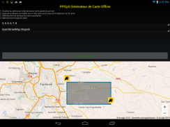
*New: Integrated Offline Map Creator
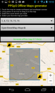
Create your offline maps with the new PPGpS Offline Map Creator.
Prepare your flight maps at home and use them where you don't have access to internet during the flight.
*FEATURES OVERVIEW:
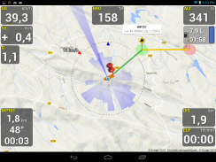
-Real time flight information
-Wind direction and speed estimation
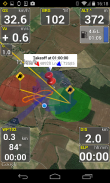
-Takeoff and Landing phases auto-detection
-Return home information (display estimated travel time and bearing)
-Fuel calculation and warning
-Emergency geo-localized SMS
-Localization with GPS
-Barometric sensor support to improve altitude accuracy
-QHN, QFE Altimeter setting
-Online and offline maps
-Offline maps creator
-Google Maps and OpenStreetMap map providers
-Rotating Map
-Log flights in KML (for Google Earth) and IGC (Leonardo servers) files
-Waypoint management
-Especially developed for Paramotor
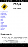
-Embedded User Manual and Tip of the day feature.
-Real time flight tracking on www.ppgps.info
-Variometer
-FlyNet2 support
*MAPS:
Online :
PPGpS can display Google or OpenStreetMap maps in connected mode.
Offline :
Download map files in your smartphone in case you don't have an internet connection during the flight.
Use the integrated PPGpS Offline Map Creator to generate offline maps.
*INSTRUMENTS:
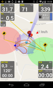
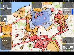
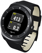
PPGpS provides the altitude, vario, bearing, magnetic compass, acceleration and ground speed.
With just one click on instruments you switch easily between different data modes : instantaneous, average and maximum values.
Altimeter can be set to actual altitude or elevation (QHN, QFE) just by longpressing on the altimeter.
If your smartphone has a barometric sensor, it could be used to compute a very accurate altitude.
*WAYPOINTS:
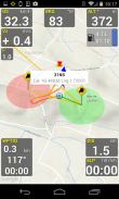
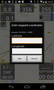
Create waypoints by tapping on the map or by entering their GPS coordinates.
Select a waypoint with one click on the waypoint instrument (WPT).
Rename or remove a waypoint from the contextual menu of the waypoint list.
Follow the displayed route (bearing, estimated travel time and distance).
Prepare your waypoints from Google Earth and import your KML files (PPGpS folder in the phone).
Waypoints may be automatically loaded at startup and saved at the end of the session.
In case your KML file doesn't import well, please send me the file and I will fix it quickly.
*WIND AND SPEEDS HUD:
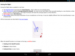
The average ground speeds are graphically displayed for every azimuth.
The wind direction is displayed (red arrow) and may be reset at any time during the flight.
*RETURN HOME:
Home direction and Estimated Travel Time to return home is always displayed (shaded red line).
Computations are done according to the wind for accurate results.
*LIVE TRACKING:
Enable the Live Tracking feature to allow your friends and family to see you live on map ! Go to www.ppgps.info for more details.
Launch the Demonstration mode to have a quick tour.
Visit www.ppgps.info
Find us at www.facebook.com/ppgps
Enjoy your PPG flights with PPGpS and thank you for your feedback.
Don't hesitate to send me your flight kml logs by mail :stephane.nicole31@gmail.com강화 된 패러 글라이더, 패러 글라이더와 초경량 비행기 조종사를위한 PPGpS, 비행 컴퓨터에 오신 것을 환영합니다
* 새로운 기능 : 통합 오프라인지도 창조주
새로운 PPGpS 오프라인지도 창조주와 오프라인지도를 만듭니다.
집에서 항공편 맵을 준비하고 비행 중에 인터넷에 액세스 할 수없는 위치를 사용합니다.
* 기능 개요 :
- 실시간 운항 정보
바람의 방향과 속도 추정
- 이착륙 단계 자동 감지
- 귀국 정보 (디스플레이 예상 이동 시간과 베어링)
연료 계산 및 경고
- 비상 지오 지역화 SMS
GPS와 지역화
고도의 정확도 향상을 위해 대기압 센서 지원
- QHn을, QFE 고도계 설정
- 온라인과 오프라인지도
- 오프라인지도 제작자
- Google지도와 OpenStreetMap의지도 제공
회전지도
(구글 어스) KML의 항공편을 로그 및 IGC (레오나르도 서버) 파일
- 웨이 포인트 관리
- 특히 하네스 개발
사용 설명서와 일 기능의 팁을 포함.
www.ppgps.info에 실시간 비행 추적
- 바리오 미터
- FlyNet2 지원
* MAPS :
온라인 :
PPGpS는 연결 모드에서 구글이나 OpenStreetMap의지도를 표시 할 수 있습니다.
오프라인 :
경우 스마트 폰에지도 파일을 다운로드 당신은 비행 중 인터넷 연결이되지 않습니다.
오프라인지도를 생성하는 통합 PPGpS 오프라인지도 작성기를 사용합니다.
* 상품 :
PPGpS는 고도, 바리오, 베어링, 자기 나침반, 가속 및지면 속도를 제공합니다.
, 순간의 평균 및 최대 값 : 상품에 대한 단 한 번의 클릭으로 당신은 다른 데이터 모드 사이를 쉽게 전환 할 수 있습니다.
고도계은 고도계에 longpressing에 의해 실제 고도 또는 높이 (QHn을, QFE)로 설정할 수 있습니다.
스마트 폰이 대기압 센서가있는 경우, 매우 정확한 고도를 계산하기 위해 사용될 수있다.
* 중간 :
지도를 눌러 또는 GPS 좌표를 입력하여 웨이 포인트를 만듭니다.
웨이 포인트 악기 (WPT)에 클릭 한 번으로 웨이 포인트를 선택합니다.
이름을 바꾸거나 웨이 포인트 목록의 상황에 맞는 메뉴에서 웨이 포인트를 제거합니다.
표시된 경로 (베어링, 예상 이동 시간 및 거리)를 따르십시오.
구글 어스에서 중간을 준비하고 KML 파일 (휴대폰 PPGpS 폴더)를 가져옵니다.
웨이 포인트가 자동으로 시작시로드와 세션이 끝날 때 저장 될 수 있습니다.
당신의 KML 파일이 잘 가져 오지 않는 경우에, 나에게 파일을 전송하고 빠르게 문제를 해결할 것입니다.
* 바람과 속도 HUD :
평균 지상 속도는 그래픽으로 모든 방위각 표시됩니다.
바람의 방향이 표시됩니다 (빨간색 화살표)과 비행 중 언제든지 다시 할 수있다.
* 귀국 :
집에 돌아 홈 방향과 예상 소요 시간은 항상 (음영 빨간 선)이 표시됩니다.
계산은 정확한 결과를 바람에 따라 수행된다.
* 라이브 추적 :
친구와 가족은 당신이지도에 살고 볼 수 있도록 실시간 추적 기능을 활성화! 자세한 내용은 www.ppgps.info로 이동합니다.
빠른 여행을 가지고 데모 모드를 시작합니다.
www.ppgps.info 방문
www.facebook.com / ppgps에서 저희를 찾아주세요
PPGpS와 함께 PPG 항공편을 즐기고 의견을 보내 주셔서 감사합니다.
우편으로 나에게 항공편 KML 로그를 보내는 것을 망설이지 않는다 : stephane.nicole31 @ gmail.com


